DISHA’s portfolio currently includes two solutions that leverage AI and dynamic data for disaster response planning.
- The Socio-Economic Mapping solution uses mobile phone data to estimate poverty levels and population movement by region.
- The Damage Assessment solution uses AI models to help identify damaged buildings from high-resolution satellite imagery following a natural disaster.
- The Refugee Settlement Mapping solution uses AI models to help extract shelter footprints in refugee settlements from high-resolution satellite imagery.
To request a demo of our products, please email disha@unglobalpulse.org.
Damage Assessment
Infrastructure damage assessments are widely used in the humanitarian sector for response planning and aid allocation following natural disasters.
DISHA’s Damage Assessment solution uses AI models to help identify damaged buildings from high-resolution satellite imagery. The use of assistive AI technology enables human analysts to assess damages significantly faster and cover a much broader impacted area than would be feasible with a manual-only approach.
This product relies on several AI models developed by Google Research, as well as an open-source SKAI model originally developed as a collaborative project of Google Research, the United Nations World Food Program (WFP) Innovation Accelerator, and InstaDeep‘s AI for Social Good (AI4SG) team.
The solution has been extensively tested and validated by the UN Satellite Center (UNOSAT) and is in operational use supporting emergency response planning. To learn more, please read our blog post.
Socio-economic Mapping
DISHA’s Socio-economic Mapping solution uses anonymized mobile network usage data refreshed daily to detect major changes in population counts by municipality, helping humanitarians understand population displacement and return trends after a disaster. In addition, by analysing call patterns and top up data, DISHA’s solution is able to estimate poverty levels by region.
The solution is live in the Philippines powered by anonymized mobile data from Globe Telecom. It has been extensively tested by Catholic Relief Services and is in operational use by UN agencies and NGOs operating in the country.
To learn more, read our blog post.

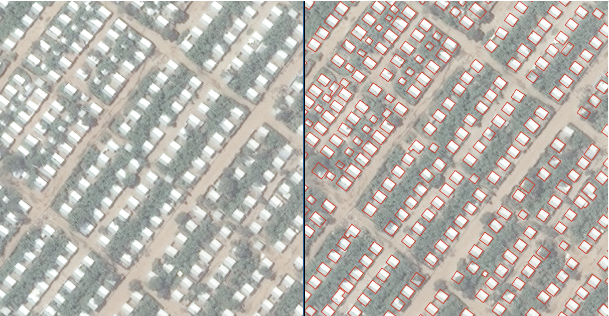
Settlement Mapping
Detailed spatial data on refugee settlements, including the location and footprint of individual shelters, is essential for site planning, service delivery, and humanitarian response. Traditionally, this data was collected manually, either by enumerator teams on the ground or by analysts digitizing settlements from satellite imagery. Both approaches are costly, slow, and difficult to keep up to date, which means that data on many of the world’s nearly 1,000 formal refugee settlements is incomplete or outdated.
DISHA’s Refugee Settlement Mapping solution uses Google’s Open Buildings model to extract shelter footprints from high-resolution satellite imagery. By offering the solution to the humanitarian community, DISHA aims to expand settlement mapping coverage and shorten update cycles compared to manual processes. The outputs are intended to support a range of operational use cases for humanitarian and development actors such as UNHCR and its partners, including building sampling frames for household surveys such as the Forced Displacement Survey, monitoring changes in settlement size and density over time, and generating baseline shelter counts in new or emerging settlements where no prior data exists.
 Paul Beaumont,

 Jerome Hodges, Chief Research Officer, Jain Family Institute
 Arden Ali, Project Lead: Digital Ethics and Governance, Jain Family Institute
 Kersten Jauer, Deputy Director, UN Secretary-General’s Office
 Gayan Peiris,
  Ankit Bisht, Partner, McKinsey & Company
 Brigitte Hoyer Gosselink,
  Vilas Dhar,