By Rajius Idzalika
Disasters displace millions of people each year. According to the Internal Displacement Monitoring Centre, 2024 saw 45.8 million new disaster-related internal displacements globally, the highest annual figure since monitoring began in 2008 and roughly double the decade average of around 22 million. Humanitarian organizations need timely, accurate displacement data for resources mobilization across affected areas. Traditional methods such as field surveys, registration at evacuation centers, and key informant interviews take days or weeks to produce estimates, and by then the response window has narrowed.
A growing body of work seeks alternatives that can operate under emergency conditions. One such avenue is big data, and in this study we focus on mobile phone data. Mobile phones offer continuous, passive observation of where people are. In many countries, mobile penetration now exceeds 100% (more SIM cards than people), and when someone’s phone connects to a cell tower it generates a record of approximate location. However, the typical approach of mobile phone data analysis is to count a person as displaced whenever they are not where they usually are.
But human mobility is more complex, and not everyone who moves is displaced. A daily commuter observed in a city center during a workday isn’t displaced from their suburban home. A local resident observed in the same location might be genuinely displaced. We fill this gap with a methodology that addresses commuter misclassification by classifying users by their typical movement patterns, such as local residents who rarely leave their area, daily commuters, and weekly commuters, each with different expected locations depending on day and time. Displacement is measured against what’s expected for each user type, not just against a single home location. A commuter observed at their workplace during business hours is behaving normally. Meanwhile, the same person observed there at midnight might indicate displacement. The weekday-weekend contrast is the signature of commuter misclassification. The two methods should converge on weekends, when nobody commutes, and diverge on weekdays, when commuters move, and that is what we see.
Mobile phone data has known biases. It represents subscribers, not the full population, and coverage varies by location and demographics. Our methodology scales from sample to rough population estimates, with uncertainty bounds that widen in areas with lower coverage or higher variability. It produces displacement rates (what percentage of an area’s population has moved from their expected location), origin-destination flows (where displaced people are going), and return dynamics (how quickly people return home after disaster impact subsides). These estimates can be generated daily, providing situational awareness that complements traditional assessment methods.
The framework is designed to extend the DISHA Socio-Economic Mapping product available to all humanitarian organizations working in the Philippines, which currently runs on aggregate mobile data for displacement detection.
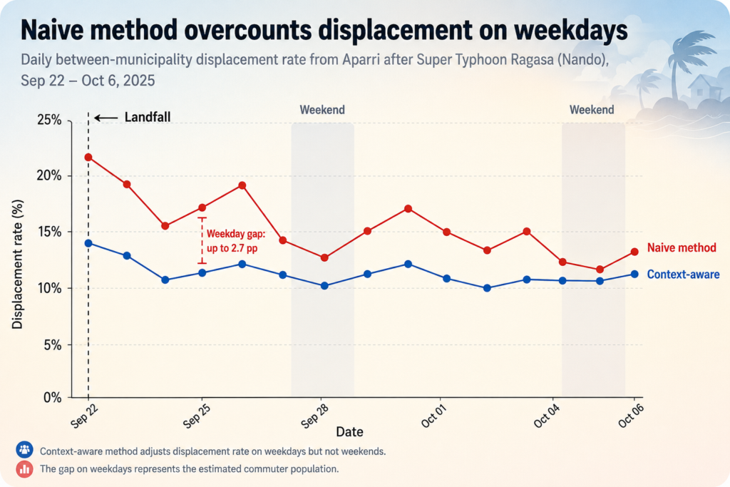
To test the framework, we applied it to Super Typhoon Ragasa (Nando), which made landfall in Calayan, Cagayan on September 22, 2025 with 215 km/h winds. We analyzed mobile phone data from a large cohort of subscribers whose baseline location included Aparri, a coastal municipality in its path. The exact sample size is withheld for privacy reasons. The commuter adjustment mattered in practice. On weekdays, the naive method overcounted displacement by 1.6 to 2.7 percentage points compared to our context-aware approach. On weekends, the two methods converged (within 0.1 pp). Our estimate of 6.5% between-municipality displacement from Aparri on September 24 was lower than the DSWD DROMIC report of 10,663 displaced persons, and by design: DROMIC counts all evacuees, including those sheltering within Aparri, while our method captures only movement across municipal boundaries.
This approach isn’t a replacement for field verification. First, mobile phone data can tell us that movement patterns changed, but not why. Someone leaving an affected area might be displaced, or might be a relief worker arriving to help. Second, the method captures between-municipality movements only. Evacuation to shelters within the same municipality is outside its scope. The Aparri case establishes proof of concept, but external validity across different country contexts, disaster types, and data environments requires further empirical testing.
We’re publishing this methodology openly to enable improvement by the research community. The full technical paper, “Context-Aware Displacement Estimation from Mobile Phone Data: A Methodological Framework,” is available on arXiv at arXiv:2604.21457.
Authors: Rajius Idzalika, Muhammad Rheza Muztahid, and Radityo Eko Prasojo work on data innovation for humanitarian response under the DISHA (Data Insight for Social and Humanitarian Actions) initiative led by UN Global Pulse and made possible by financial support from Google.org and the Patrick J. McGovern Foundation, building on prior research by Pulse Lab Jakarta.
Globe Telecom provided the de-identified mobile phone data.
We thank McKinsey and Company for their collaboration which informed the development of this methodological framework.
 Paul Beaumont,

 Jerome Hodges, Chief Research Officer, Jain Family Institute
 Arden Ali, Project Lead: Digital Ethics and Governance, Jain Family Institute
 Kersten Jauer, Deputy Director, UN Secretary-General’s Office
 Gayan Peiris,
  Ankit Bisht, Partner, McKinsey & Company
 Brigitte Hoyer Gosselink,
  Vilas Dhar,